


Petite Moucherolle

GOHIER
User
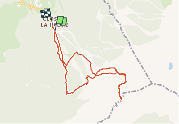

Length
10.2 km

Max alt
2057 m

Uphill gradient
897 m
Km-Effort
22 km

Min alt
1236 m

Downhill gradient
904 m
Boucle
No
Creation date :
2021-02-20 07:47:12.0
Updated on :
2021-02-21 07:18:24.086
6h03
Difficulty : Unknown

FREE GPS app for hiking
 SityTrail
IGN / Geographical institutes
SityTrail Plus
The world is yours!
About
Trail Touring skiing of 10.2 km to be discovered at Auvergne-Rhône-Alpes, Isère, Corrençon-en-Vercors. This trail is proposed by GOHIER.
Description
Avec Sandrine, Bruno et Patricia.
Grand beau mais vent de folie qui finit par tomber presque entièrement avant le sommet.
Bonne neige revenue.
Positioning
Country:
France
Region :
Auvergne-Rhône-Alpes
Department/Province :
Isère
Municipality :
Corrençon-en-Vercors
Location:
Unknown
Start:(Dec)
Start:(UTM)
699368 ; 4988028 (31T) N.
Comments