Trail Mountain bike Collonges-la-Rouge - Collonges - La Rouge / Meyssac / Lagleygeolle  - Photo

Collonges - La Rouge / Meyssac / Lagleygeolle

 Gpoujade
Gpoujade

User

© OpenStreetMap contributors
Length
Length
25 km
Max alt
Max alt
494 m
Uphill gradient
Uphill gradient
721 m
Km-Effort
Km-Effort  
35 km
Min alt
Min alt
152 m
Downhill gradient
Downhill gradient
713 m
Boucle
Boucle
Yes
Creation date :
2021-02-22 13:01:31.895
Updated on :
2021-08-12 14:39:05.89

(1 Reviews)

Mountain bike
Mountain bike
1h53
Difficulty : Medium

Scan this QR Code to open this trail in the SityTrail application

FREE GPS app for hiking

Logo SityTrail SityTrail

IGN / Geographical institutes

Download SityTrail from the App Store Download SityTrail from Google Play

Logo SityTrail SityTrail World

The world is yours!

Download SityTrail from the App Store Download SityTrail from Google Play Download SityTrail on Huawei AppGallery

About

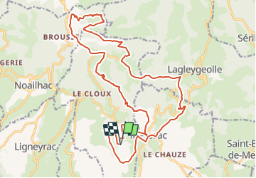
Trail Mountain bike of 25 km to be discovered at New Aquitaine, Corrèze, Collonges-la-Rouge. This trail is proposed by Gpoujade.

Description

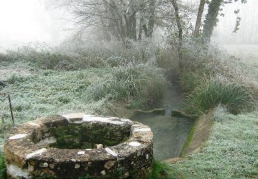
Boucle au départ du Village de Vacances de Collonges qui nous amène sur les hauteurs de cette commune et qui passe par Orgnac avec ses étangs et le départ de son souterrain . Superbes beaux points de vues et petits sentiers typiques corréziens  

Elevation profile

Positioning

Country:
France
Region :
New Aquitaine
Department/Province :
Corrèze
Municipality :
Collonges-la-Rouge
Location:
Unknown
Start:(UTM)
394560 ; 4989633 (31T) N.

Comments

Please log in to post a review or rate the element


Super


Trails nearby

Trail Mountain bike Ligneyrac - Circuit de la Vicomté de Turenne - Photo
Mountain bike
sdroneau

Mountain bike

Difficult
(2)
Ligneyrac, New Aquitaine, Corrèze, France
30 km | 43 km-effort
3h 30min
Yes
Trail Mountain bike Chauffour-sur-Vell - Le bois de l'empire - Photo
Mountain bike
sdroneau

Mountain bike

Difficult
(1)
Chauffour-sur-Vell, New Aquitaine, Corrèze, France
26 km | 34 km-effort
3h 0min
Yes
Trail Walking Noailhac - Balade autour de Noailhac - Photo
Walking
sdroneau

Walking

Difficult
(2)
Noailhac, New Aquitaine, Corrèze, France
14.7 km | 21 km-effort
4h 0min
Yes
Trail Mountain bike Chauffour-sur-Vell - Aux confins du Quercy - Chauffour sur Vell - Pays de la vallée de la Dordogne Corrézienne  - Photo
Mountain bike
tracegps

Mountain bike

Medium
(1)
Chauffour-sur-Vell, New Aquitaine, Corrèze, France
15.5 km | 18.7 km-effort
1h 19min
Yes
Trail Mountain bike Meyssac - Boucle de Meyssac à Beynat   - Photo
Mountain bike
Gpoujade

Mountain bike

Difficult
(1)
Meyssac, New Aquitaine, Corrèze, France
40 km | 53 km-effort
3h 0min
Yes
Trail Mountain bike Chauffour-sur-Vell - 2019-12-28_17h26m41_L'Hôpital(32km) - Photo
Mountain bike
Gpoujade

Mountain bike

Difficult
(1)
Chauffour-sur-Vell, New Aquitaine, Corrèze, France
32 km | 41 km-effort
2h 48min
Yes
Trail Mountain bike Chauffour-sur-Vell - curemonte/Collonges:la boucle verte - Photo
Mountain bike
fesseneric

Mountain bike

Medium
(1)
Chauffour-sur-Vell, New Aquitaine, Corrèze, France
31 km | 39 km-effort
2h 31min
Yes
Trail Walking Collonges-la-Rouge - colonge - Photo
Walking
GUIDE
Nordic33

Walking

Medium
Collonges-la-Rouge, New Aquitaine, Corrèze, France
6.1 km | 9.3 km-effort
1h 54min
Yes
Trail Mountain bike Meyssac - Sortie du 6 juin 2021 - Photo
Mountain bike
Gpoujade

Mountain bike

Difficult
(1)
Meyssac, New Aquitaine, Corrèze, France
27 km | 35 km-effort
2h 34min
Yes


Close
My subscriptions