


PHR TM Day 39

ARVIEU
User
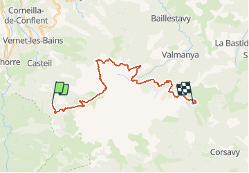

Length
27 km

Max alt
2753 m

Uphill gradient
1522 m
Km-Effort
48 km

Min alt
1464 m

Downhill gradient
1747 m
Boucle
No
Creation date :
2021-02-22 14:29:26.844
Updated on :
2021-02-22 14:30:48.617
10h53
Difficulty : Very difficult

FREE GPS app for hiking
 SityTrail
IGN / Geographical institutes
SityTrail Plus
The world is yours!
About
Trail Walking of 27 km to be discovered at Occitania, Pyrénées-Orientales, Casteil. This trail is proposed by ARVIEU.
Positioning
Country:
France
Region :
Occitania
Department/Province :
Pyrénées-Orientales
Municipality :
Casteil
Location:
Unknown
Start:(Dec)
Start:(UTM)
451337 ; 4705652 (31T) N.
Comments