


La Chambotte

GioA10
User
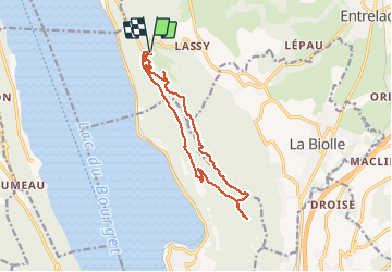

Length
14.7 km

Max alt
847 m

Uphill gradient
590 m
Km-Effort
23 km

Min alt
517 m

Downhill gradient
591 m
Boucle
Yes
Creation date :
2021-02-23 09:10:24.0
Updated on :
2021-02-23 14:27:13.326
4h19
Difficulty : Easy

FREE GPS app for hiking
 SityTrail
IGN / Geographical institutes
SityTrail Plus
The world is yours!
About
Trail Walking of 14.7 km to be discovered at Auvergne-Rhône-Alpes, Savoy, Entrelacs. This trail is proposed by GioA10.
Photos


Positioning
Country:
France
Region :
Auvergne-Rhône-Alpes
Department/Province :
Savoy
Municipality :
Entrelacs
Location:
Saint-Germain-la-Chambotte
Start:(Dec)
Start:(UTM)
723486 ; 5073277 (31T) N.
Comments