


Ruederbach-Hirzingue

JCLUTT
User
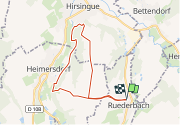

Length
7.5 km

Max alt
402 m

Uphill gradient
119 m
Km-Effort
9 km

Min alt
337 m

Downhill gradient
119 m
Boucle
Yes
Creation date :
2021-02-23 14:55:34.235
Updated on :
2021-05-26 13:19:48.519
2h03
Difficulty : Easy

FREE GPS app for hiking
 SityTrail
IGN / Geographical institutes
SityTrail Plus
The world is yours!
About
Trail Walking of 7.5 km to be discovered at Grand Est, Haut-Rhin, Ruederbach. This trail is proposed by JCLUTT.

Positioning
Country:
France
Region :
Grand Est
Department/Province :
Haut-Rhin
Municipality :
Ruederbach
Location:
Unknown
Start:(Dec)
Start:(UTM)
369755 ; 5269355 (32T) N.
Comments