


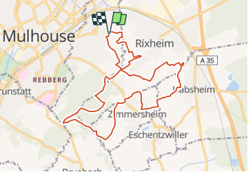
Circuit Footing

JCLUTT
User

Length
21 km

Max alt
371 m

Uphill gradient
385 m
Km-Effort
26 km

Min alt
258 m

Downhill gradient
385 m
Boucle
Yes
Creation date :
2021-02-23 15:20:48.71
Updated on :
2021-05-26 13:19:21.28
--
Difficulty : Difficult

FREE GPS app for hiking
 SityTrail
IGN / Geographical institutes
SityTrail Plus
The world is yours!
About
Trail Running of 21 km to be discovered at Grand Est, Haut-Rhin, Riedisheim. This trail is proposed by JCLUTT.

Positioning
Country:
France
Region :
Grand Est
Department/Province :
Haut-Rhin
Municipality :
Riedisheim
Location:
Unknown
Start:(Dec)
Start:(UTM)
378150 ; 5289494 (32T) N.
Comments