


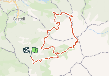
Pyrenees-Or - Le tour du Canigou 27km 1530m

RandoVal
User


--
Difficulty : Unknown

FREE GPS app for hiking
 SityTrail
IGN / Geographical institutes
SityTrail Plus
The world is yours!
About
Trail Walking of 27 km to be discovered at Occitania, Pyrénées-Orientales, Casteil. This trail is proposed by RandoVal.
Description
Le tour du Canigou en boucle. Stationnement et départ prés du refuge forestier de Mariailles que l'on rejoint par Vernet-les-Bains, Casteil et le Col de Jou. Sens Anti-horaire. on démarre pour rejoindre le torrent du Cadi, au Roc du Cadi on prend à droite vers le refuge Arago, la plaine de Cadi nous emmène jusqu'au pied du Canigou près de la Brèche Durier, on monte au sommet par la cheminée (faut mettre les mains), arrivé en haut vous verrez ... du monde, c'est plus facile par le coté nord que l'on prend pour le retour vers le Pic Joffre, ensuite à gauche vers le refuge de Bonne Aigues et on suit les GR10 et GR 36 pour rentrer.
Positioning
Comments