


TRK000

JCLUTT
User
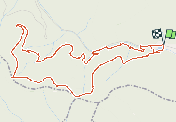

Length
7.8 km

Max alt
727 m

Uphill gradient
351 m
Km-Effort
12.5 km

Min alt
382 m

Downhill gradient
351 m
Boucle
Yes
Creation date :
2021-02-23 18:43:40.819
Updated on :
2021-02-23 18:47:51.46
2h50
Difficulty : Medium

FREE GPS app for hiking
 SityTrail
IGN / Geographical institutes
SityTrail Plus
The world is yours!
About
Trail Walking of 7.8 km to be discovered at Grand Est, Haut-Rhin, Thann. This trail is proposed by JCLUTT.
Positioning
Country:
France
Region :
Grand Est
Department/Province :
Haut-Rhin
Municipality :
Thann
Location:
Unknown
Start:(Dec)
Start:(UTM)
356813 ; 5296680 (32T) N.
Comments