


Saint Sorlin lesChoseaux la Croix de Fer,le Glandon,la vallée d Olle .

lecmic
User
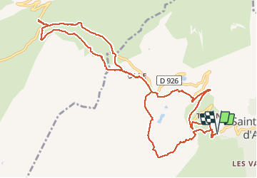

Length
13.1 km

Max alt
2089 m

Uphill gradient
729 m
Km-Effort
23 km

Min alt
1635 m

Downhill gradient
729 m
Boucle
Yes
Creation date :
2021-02-25 07:18:19.201
Updated on :
2021-02-25 13:20:32.332
5h44
Difficulty : Difficult

FREE GPS app for hiking
 SityTrail
IGN / Geographical institutes
SityTrail Plus
The world is yours!
About
Trail Snowshoes of 13.1 km to be discovered at Auvergne-Rhône-Alpes, Savoy, Saint-Sorlin-d'Arves. This trail is proposed by lecmic.
Description
rando raquettes avec vue superbe
Positioning
Country:
France
Region :
Auvergne-Rhône-Alpes
Department/Province :
Savoy
Municipality :
Saint-Sorlin-d'Arves
Location:
Unknown
Start:(Dec)
Start:(UTM)
281612 ; 5011194 (32T) N.
Comments