


Traversée des pyrénées

harydh
User GUIDE
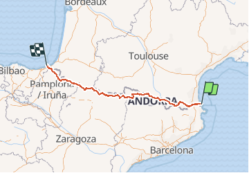

Length
734 km

Max alt
2972 m

Uphill gradient
46637 m
Km-Effort
1356 km

Min alt
-1 m

Downhill gradient
46632 m
Boucle
No
Creation date :
2021-02-26 10:12:16.147
Updated on :
2021-02-26 10:18:10.42
--
Difficulty : Unknown

FREE GPS app for hiking
 SityTrail
IGN / Geographical institutes
SityTrail Plus
The world is yours!
About
Trail Trail of 734 km to be discovered at Occitania, Pyrénées-Orientales, Banyuls-sur-Mer. This trail is proposed by harydh.
Positioning
Country:
France
Region :
Occitania
Department/Province :
Pyrénées-Orientales
Municipality :
Banyuls-sur-Mer
Location:
Unknown
Start:(Dec)
Start:(UTM)
510628 ; 4703309 (31T) N.
Comments
3a2zeo