


le crey du quart

laurentnecca
User
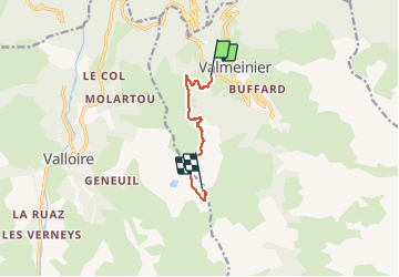

Length
5.8 km

Max alt
2514 m

Uphill gradient
973 m
Km-Effort
15.5 km

Min alt
1538 m

Downhill gradient
0 m
Boucle
No
Creation date :
2021-02-26 08:44:42.489
Updated on :
2021-02-26 13:31:10.853
2h31
Difficulty : Difficult

FREE GPS app for hiking
 SityTrail
IGN / Geographical institutes
SityTrail Plus
The world is yours!
About
Trail Touring skiing of 5.8 km to be discovered at Auvergne-Rhône-Alpes, Savoy, Valmeinier. This trail is proposed by laurentnecca.
Positioning
Country:
France
Region :
Auvergne-Rhône-Alpes
Department/Province :
Savoy
Municipality :
Valmeinier
Location:
Unknown
Start:(Dec)
Start:(UTM)
301499 ; 5006432 (32T) N.
Comments