


MITTELWIHR zellenberg

jcschubnel
User
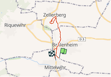

Length
5 km

Max alt
298 m

Uphill gradient
75 m
Km-Effort
6.1 km

Min alt
219 m

Downhill gradient
103 m
Boucle
Yes
Creation date :
2021-03-01 12:30:26.044
Updated on :
2021-03-01 15:12:10.468
2h00
Difficulty : Very easy

FREE GPS app for hiking
 SityTrail
IGN / Geographical institutes
SityTrail Plus
The world is yours!
About
Trail Walking of 5 km to be discovered at Grand Est, Haut-Rhin, Beblenheim. This trail is proposed by jcschubnel.
Positioning
Country:
France
Region :
Grand Est
Department/Province :
Haut-Rhin
Municipality :
Beblenheim
Location:
Unknown
Start:(Dec)
Start:(UTM)
375257 ; 5334748 (32U) N.
Comments