


OSENBACH

jcschubnel
User
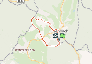

Length
5.2 km

Max alt
442 m

Uphill gradient
162 m
Km-Effort
7.3 km

Min alt
323 m

Downhill gradient
163 m
Boucle
Yes
Creation date :
2021-02-21 13:37:40.526
Updated on :
2021-03-01 15:52:13.972
1h37
Difficulty : Very easy

FREE GPS app for hiking
 SityTrail
IGN / Geographical institutes
SityTrail Plus
The world is yours!
About
Trail Walking of 5.2 km to be discovered at Grand Est, Haut-Rhin, Osenbach. This trail is proposed by jcschubnel.
Positioning
Country:
France
Region :
Grand Est
Department/Province :
Haut-Rhin
Municipality :
Osenbach
Location:
Unknown
Start:(Dec)
Start:(UTM)
367088 ; 5315691 (32T) N.
Comments