


les karellis

lecmic
User
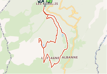

Length
10.6 km

Max alt
2132 m

Uphill gradient
590 m
Km-Effort
18.5 km

Min alt
1593 m

Downhill gradient
589 m
Boucle
Yes
Creation date :
2021-03-02 07:26:57.819
Updated on :
2021-03-02 12:09:00.946
4h12
Difficulty : Medium

FREE GPS app for hiking
 SityTrail
IGN / Geographical institutes
SityTrail Plus
The world is yours!
About
Trail Snowshoes of 10.6 km to be discovered at Auvergne-Rhône-Alpes, Savoy, Montricher-Albanne. This trail is proposed by lecmic.
Description
rando raquettes les karellis, le belvédére, le bec de l aigle, albanne, lac de pramol
Positioning
Country:
France
Region :
Auvergne-Rhône-Alpes
Department/Province :
Savoy
Municipality :
Montricher-Albanne
Location:
Montricher-le-Bochet
Start:(Dec)
Start:(UTM)
296324 ; 5011463 (32T) N.
Comments