


Mandelberg

pascalloos
User
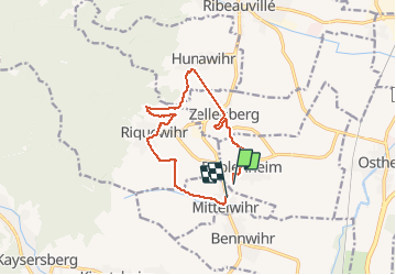

Length
11.5 km

Max alt
378 m

Uphill gradient
260 m
Km-Effort
15 km

Min alt
215 m

Downhill gradient
272 m
Boucle
No
Creation date :
2021-03-02 09:37:41.509
Updated on :
2021-03-02 14:04:13.28
3h07
Difficulty : Very easy

FREE GPS app for hiking
 SityTrail
IGN / Geographical institutes
SityTrail Plus
The world is yours!
About
Trail Walking of 11.5 km to be discovered at Grand Est, Haut-Rhin, Beblenheim. This trail is proposed by pascalloos.
Description
Mittelwihr, beblenheim, zellenberg,
Hunawihr riquewihr
Positioning
Country:
France
Region :
Grand Est
Department/Province :
Haut-Rhin
Municipality :
Beblenheim
Location:
Unknown
Start:(Dec)
Start:(UTM)
375289 ; 5334892 (32U) N.
Comments