


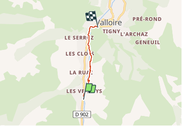
Descente jusqu’à valloire

aemilon
User

Length
2.5 km

Max alt
1571 m

Uphill gradient
7 m
Km-Effort
3 km

Min alt
1425 m

Downhill gradient
142 m
Boucle
No
Creation date :
2021-03-02 13:43:28.0
Updated on :
2021-03-02 14:51:44.978
1h07
Difficulty : Unknown

FREE GPS app for hiking
 SityTrail
IGN / Geographical institutes
SityTrail Plus
The world is yours!
About
Trail Walking of 2.5 km to be discovered at Auvergne-Rhône-Alpes, Savoy, Valloire. This trail is proposed by aemilon.
Positioning
Country:
France
Region :
Auvergne-Rhône-Alpes
Department/Province :
Savoy
Municipality :
Valloire
Location:
Unknown
Start:(Dec)
Start:(UTM)
297211 ; 5002467 (32T) N.
Comments