


RHONE: VIONS - CHANAZ

djeepee74
User
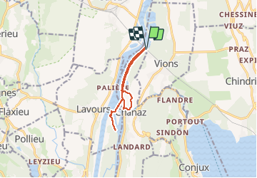

Length
9.1 km

Max alt
240 m

Uphill gradient
42 m
Km-Effort
9.7 km

Min alt
231 m

Downhill gradient
42 m
Boucle
Yes
Creation date :
2021-03-05 12:24:44.097
Updated on :
2021-03-10 16:37:24.485
2h25
Difficulty : Very easy

FREE GPS app for hiking
 SityTrail
IGN / Geographical institutes
SityTrail Plus
The world is yours!
About
Trail Walking of 9.1 km to be discovered at Auvergne-Rhône-Alpes, Savoy, Vions. This trail is proposed by djeepee74.
Description
BOUCLE live 20210305
Positioning
Country:
France
Region :
Auvergne-Rhône-Alpes
Department/Province :
Savoy
Municipality :
Vions
Location:
Unknown
Start:(Dec)
Start:(UTM)
717357 ; 5078940 (31T) N.
Comments