Trail Walking Villars - BOUCLE DE VILLARD 10km - Photo

BOUCLE DE VILLARD 10km

 DDESLAN
DDESLAN

User

© OpenStreetMap contributors
Length
Length
10.2 km
Max alt
Max alt
213 m
Uphill gradient
Uphill gradient
181 m
Km-Effort
Km-Effort  
12.6 km
Min alt
Min alt
136 m
Downhill gradient
Downhill gradient
181 m
Boucle
Boucle
Yes
Creation date :
2021-03-08 19:47:08.413
Updated on :
2021-03-08 19:51:52.713

(1 Reviews)

Walking
Walking
2h56
Difficulty : Easy

Scan this QR Code to open this trail in the SityTrail application

FREE GPS app for hiking

Logo SityTrail SityTrail

IGN / Geographical institutes

Download SityTrail from the App Store Download SityTrail from Google Play

Logo SityTrail SityTrail World

The world is yours!

Download SityTrail from the App Store Download SityTrail from Google Play Download SityTrail on Huawei AppGallery

About

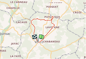
Trail Walking of 10.2 km to be discovered at New Aquitaine, Dordogne, Villars. This trail is proposed by DDESLAN.

Elevation profile

Positioning

Country:
France
Region :
New Aquitaine
Department/Province :
Dordogne
Municipality :
Villars
Location:
Unknown
Start:(UTM)
324236 ; 5032083 (31T) N.

Comments

Please log in to post a review or rate the element


Randonnée à éviter, certains tracés se perdent dans les bois et traversent des propriétés privés.


Trails nearby

Trail Walking Villars - Puyguilhem - Grotte de Villars - Photo
Walking
Zygomat

Walking

Difficult
(1)
Villars, New Aquitaine, Dordogne, France
13.6 km | 17.1 km-effort
3h 44min
Yes
Trail Walking Villars - Villars Quinsac - Photo
Walking
YV24

Walking

Easy
(1)
Villars, New Aquitaine, Dordogne, France
13 km | 16.3 km-effort
3h 30min
Yes
Trail Electric bike Villars - Villars -Nontron 10/09/22 - Photo
Electric bike
zoe.vienne

Electric bike

Easy
Villars, New Aquitaine, Dordogne, France
34 km | 41 km-effort
2h 40min
No
Trail Walking Villars - Villars abbaye de Boschaud - Photo
Walking
rougilabuse

Walking

Medium
Villars, New Aquitaine, Dordogne, France
12.4 km | 15.8 km-effort
3h 58min
Yes
Trail Walking Champagnac-de-Belair - Boucle de Champagnac de bel air - Photo
Walking
Patricew

Walking

Difficult
Champagnac-de-Belair, New Aquitaine, Dordogne, France
12.7 km | 15.7 km-effort
3h 33min
Yes
Trail Mountain bike Villars - Mareuil Pauliac Brantôme Pressillac - Photo
Mountain bike
charrier

Mountain bike

Medium
Villars, New Aquitaine, Dordogne, France
109 km | 136 km-effort
8h 23min
Yes
Trail Walking Saint-Pierre-de-Côle - St Pierre de Côle Bruzac courte 12km - Photo
Walking
YV24

Walking

Easy
Saint-Pierre-de-Côle, New Aquitaine, Dordogne, France
11.5 km | 14.5 km-effort
3h 10min
Yes
Trail Walking Condat-sur-Trincou - Condat-sur-Trincou Dronne Trincou 13km - Photo
Walking
YV24

Walking

Easy
Condat-sur-Trincou, New Aquitaine, Dordogne, France
12.6 km | 15.8 km-effort
3h 26min
Yes
Trail Walking Champagnac-de-Belair - Champagnac Belair Drone Trincou - Photo
Walking
YV24

Walking

Easy
Champagnac-de-Belair, New Aquitaine, Dordogne, France
13.4 km | 16.7 km-effort
3h 36min
Yes


Close
My subscriptions