![](/images/other/stat-length.png)
![Trail Walking Stavelot - 2021-03-10_14h59m08_1227 - Photo](https://media.geolcdn.com/t/1900/400/ext.pjpeg?maxdim=2&url=https%3A%2F%2Fmedia.geolcdn.com%2Ff%2F8b34c446-55a9-478c-88d7-9cb986b390fb.jpg)
2021-03-10_14h59m08_1227
mumu.larandonneuse
User GUIDE
![Length](/images/other/stat-length.png)
Length
18.8 km
![Max alt](https://static1.geolcdn.com/siteimages/upload/files/1508320355ic_sort_altitude_max_24dp.png)
Max alt
509 m
![Uphill gradient](https://static1.geolcdn.com/siteimages/upload/files/1508320355ic_sort_den_pos_24dp.png)
Uphill gradient
537 m
![Km-Effort](/images/other/stat-length.png)
Km-Effort
26 km
![Min alt](https://static1.geolcdn.com/siteimages/upload/files/1508320355ic_sort_altitude_min_24dp.png)
Min alt
250 m
![Downhill gradient](https://static1.geolcdn.com/siteimages/upload/files/1508320355ic_sort_den_neg_24dp.png)
Downhill gradient
536 m
![Boucle](https://static1.geolcdn.com/siteimages/upload/files/16400158638029165_repeat_loop_refresh_sync_direction_icon.png)
Boucle
No
Creation date :
2021-03-10 13:59:08.872
Updated on :
2021-03-20 15:33:06.479
![Walking](https://static1.geolcdn.com/sitytour/trail-icons/101.png)
5h53
Difficulty : Difficult
![Scan this QR Code to open this trail in the SityTrail application](https://capi.geolives.com/qq0zvz2zws4bq2lad0pu/sitytour/trails/2702494/qr.png?size=200)
FREE GPS app for hiking
About
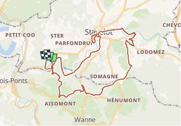
Trail Walking of 18.8 km to be discovered at Wallonia, Liège, Stavelot. This trail is proposed by mumu.larandonneuse.
Description
Magnifique parcours.
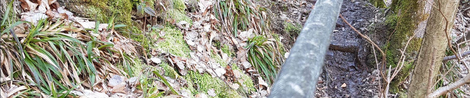
⚠️ Réservé aux marcheurs expérimentés car il faut grimper un sentier rocailleux à l'aide de cordes.
📌 Domaine Longpré, route de Trois-Ponts 175 à Stavelot.
ℹ sur www.wandelgidszuidlimburg.com n° 1227
Positioning
Country:
Belgium
Region :
Wallonia
Department/Province :
Liège
Municipality :
Stavelot
Location:
Stavelot
Start:(Dec)
Start:(UTM)
705769 ; 5584677 (31U) N.
Comments
Trails nearby
![Trail Walking Trois-Ponts - RB-Lg-29_Wanne - Photo](https://media.geolcdn.com/t/375/260/ext.jpg?maxdim=2&url=https%3A%2F%2Fservices.sitytrail.com%2FGeolivesWS%2FDownloadMedia.ashx%3FTrailID%3D402097%26Media%3Dd4589c74-2522-4a62-866b-b5d0038bf075.jpg)
![Walking Walking](https://static1.geolcdn.com/sitytour/trail-icons/101.png)
![Trail Walking Trois-Ponts - RB-Lg-27_Trois-Ponts - Photo](https://media.geolcdn.com/t/375/260/ext.jpg?maxdim=2&url=https%3A%2F%2Fservices.sitytrail.com%2FGeolivesWS%2FDownloadMedia.ashx%3FTrailID%3D402090%26Media%3Ddb9e80d9-8efc-4045-abb6-cee4f6885ea2.jpg)
![Walking Walking](https://static1.geolcdn.com/sitytour/trail-icons/101.png)
RB-Lg-27_Trois-Ponts
Walking
(7)
Trois-Ponts,
Wallonia,
Liège,
Belgium
![](/images/other/stat-length.png)
23 km | 33 km-effort
7h 30min
![](https://static1.geolcdn.com/siteimages/upload/files/16400158638029165_repeat_loop_refresh_sync_direction_icon.png)
Yes
![Trail Walking Trois-Ponts - Logbiermé. Natura 2000, des sites qui valent le détour ! Lg5 - Photo](https://media.geolcdn.com/t/375/260/ext.jpg?maxdim=2&url=https%3A%2F%2Fservices.sitytrail.com%2FGeolivesWS%2FDownloadMedia.ashx%3FTrailID%3D142605%26Media%3Db59446be-93ad-402a-bf6d-b5189e61bcf2.JPG)
![Walking Walking](https://static1.geolcdn.com/sitytour/trail-icons/101.png)
Logbiermé. Natura 2000, des sites qui valent le détour ! Lg5
Walking
Easy
(10)
Trois-Ponts,
Wallonia,
Liège,
Belgium
![](/images/other/stat-length.png)
8.4 km | 10.9 km-effort
Unknown
![](https://static1.geolcdn.com/siteimages/upload/files/16400158638029165_repeat_loop_refresh_sync_direction_icon.png)
Yes
![Trail Walking Stavelot - 2021-06-30_12h14m27_stavelot_13km_new - Photo](https://media.geolcdn.com/t/375/260/ext.jpg?maxdim=2&url=https%3A%2F%2Fmedia.geolcdn.com%2Ff%2Facb4a21b-3ac7-4958-9a44-c1358ae78040.jpg)
![Walking Walking](https://static1.geolcdn.com/sitytour/trail-icons/101.png)
2021-06-30_12h14m27_stavelot_13km_new
Walking
Medium
(2)
Stavelot,
Wallonia,
Liège,
Belgium
![](/images/other/stat-length.png)
13.4 km | 19.8 km-effort
4h 30min
![](https://static1.geolcdn.com/siteimages/upload/files/16400158638029165_repeat_loop_refresh_sync_direction_icon.png)
Yes
![Trail Walking Stoumont - IR-224 & RB-SoirMag-06_La-Glaise-_QR3_Rac1Rac2_13_9_km - Photo](https://media.geolcdn.com/t/375/260/ext.jpg?maxdim=2&url=https%3A%2F%2Fmedia.geolcdn.com%2Ff%2Fc833c403-820e-4132-8cfd-95c8fa336790.JPG)
![Walking Walking](https://static1.geolcdn.com/sitytour/trail-icons/101.png)
IR-224 & RB-SoirMag-06_La-Glaise-_QR3_Rac1Rac2_13_9_km
Walking
Medium
(2)
Stoumont,
Wallonia,
Liège,
Belgium
![](/images/other/stat-length.png)
13.9 km | 19.8 km-effort
4h 30min
![](https://static1.geolcdn.com/siteimages/upload/files/16400158638029165_repeat_loop_refresh_sync_direction_icon.png)
Yes
![Trail Walking Stoumont - 2021-03-12_16h39m43_LaGleizeP3TourduMontSaintVictor - Photo](https://media.geolcdn.com/t/375/260/ext.jpg?maxdim=2&url=https%3A%2F%2Fmedia.geolcdn.com%2Ff%2Feeda461f-0b98-4912-915c-63b0e2025382.jpg)
![Walking Walking](https://static1.geolcdn.com/sitytour/trail-icons/101.png)
2021-03-12_16h39m43_LaGleizeP3TourduMontSaintVictor
Walking
Medium
(2)
Stoumont,
Wallonia,
Liège,
Belgium
![](/images/other/stat-length.png)
15.8 km | 22 km-effort
5h 2min
![](https://static1.geolcdn.com/siteimages/upload/files/16400158638029165_repeat_loop_refresh_sync_direction_icon.png)
Yes
![Trail Walking Trois-Ponts - RB-Lg-27_Trois-Ponts_via-racc - Photo](https://media.geolcdn.com/t/375/260/ext.jpg?maxdim=2&url=https%3A%2F%2Fservices.sitytrail.com%2FGeolivesWS%2FDownloadMedia.ashx%3FTrailID%3D402091%26Media%3Ddb9e80d9-8efc-4045-abb6-cee4f6885ea2.jpg)
![Walking Walking](https://static1.geolcdn.com/sitytour/trail-icons/101.png)
RB-Lg-27_Trois-Ponts_via-racc
Walking
Very difficult
(1)
Trois-Ponts,
Wallonia,
Liège,
Belgium
![](/images/other/stat-length.png)
16.9 km | 25 km-effort
5h 36min
![](https://static1.geolcdn.com/siteimages/upload/files/16400158638029165_repeat_loop_refresh_sync_direction_icon.png)
Yes
![Trail Walking Stavelot - Chemin des Sources |stage 3 STAVELOT - HOCKAI - Photo](https://media.geolcdn.com/t/375/260/ext.jpg?maxdim=2&url=https%3A%2F%2Fmedia.geolcdn.com%2Ff%2F77791607-24fa-4b91-a259-1d28dbfa8616.jpg)
![Walking Walking](https://static1.geolcdn.com/sitytour/trail-icons/101.png)
Chemin des Sources |stage 3 STAVELOT - HOCKAI
Walking
Very difficult
(1)
Stavelot,
Wallonia,
Liège,
Belgium
![](/images/other/stat-length.png)
19 km | 25 km-effort
5h 45min
![](https://static1.geolcdn.com/siteimages/upload/files/16400158638029165_repeat_loop_refresh_sync_direction_icon.png)
No
![Trail Walking Lierneux - rando reharmont 6/11/2020 - Photo](https://media.geolcdn.com/t/375/260/ext.jpg?maxdim=2&url=https%3A%2F%2Fmedia.geolcdn.com%2Ff%2Fc172c759-425c-4a1d-95a3-aaadcf59b477.jpg)
![Walking Walking](https://static1.geolcdn.com/sitytour/trail-icons/101.png)
rando reharmont 6/11/2020
Walking
Medium
(2)
Lierneux,
Wallonia,
Liège,
Belgium
![](/images/other/stat-length.png)
18.4 km | 25 km-effort
4h 34min
![](https://static1.geolcdn.com/siteimages/upload/files/16400158638029165_repeat_loop_refresh_sync_direction_icon.png)
Yes
prachtige wandeling. een paar.pittige klimmers.
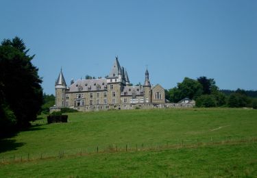
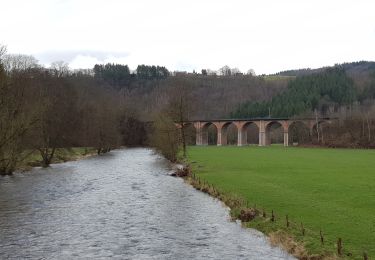
Beaux paysages et forêts féeriques
Superbe parcours avec quasi de l'escalade au début avec l'aide de cordes.