


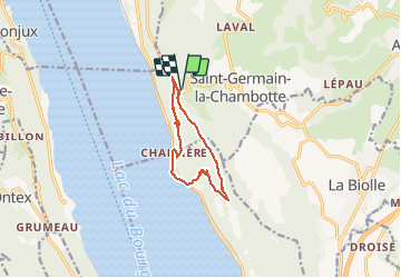
MONT DE CORSUET: CHAMBOTTE - BRISON (retour par les vignes)

djeepee74
User

Length
9.6 km

Max alt
688 m

Uphill gradient
536 m
Km-Effort
16.7 km

Min alt
230 m

Downhill gradient
536 m
Boucle
Yes
Creation date :
2021-03-10 12:22:40.0
Updated on :
2021-04-03 18:54:32.111
2h45
Difficulty : Medium

FREE GPS app for hiking
 SityTrail
IGN / Geographical institutes
SityTrail Plus
The world is yours!
About
Trail Walking of 9.6 km to be discovered at Auvergne-Rhône-Alpes, Savoy, Entrelacs. This trail is proposed by djeepee74.
Description
BOUCLE live 20210310
Positioning
Country:
France
Region :
Auvergne-Rhône-Alpes
Department/Province :
Savoy
Municipality :
Entrelacs
Location:
Saint-Germain-la-Chambotte
Start:(Dec)
Start:(UTM)
723391 ; 5073297 (31T) N.
Comments