


SityTrail - ARESSY Le platrau d'Aressy M2

mitch1952
User
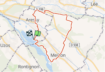

Length
8.4 km

Max alt
251 m

Uphill gradient
78 m
Km-Effort
9.4 km

Min alt
186 m

Downhill gradient
79 m
Boucle
Yes
Creation date :
2021-03-14 17:05:50.791
Updated on :
2022-06-08 10:37:17.992
2h10
Difficulty : Easy

FREE GPS app for hiking
 SityTrail
IGN / Geographical institutes
SityTrail Plus
The world is yours!
About
Trail On foot of 8.4 km to be discovered at New Aquitaine, Pyrénées-Atlantiques, Aressy. This trail is proposed by mitch1952.
Description
reco faite le 01/03/2021 légère variante par rapport a la trace origine 500 m environ apres le départ le sentier suit le bord du gave (modification du terrain suite a des innondations ?)
Positioning
Country:
France
Region :
New Aquitaine
Department/Province :
Pyrénées-Atlantiques
Municipality :
Aressy
Location:
Unknown
Start:(Dec)
Start:(UTM)
716902 ; 4794517 (30T) N.
Comments