Trail Horseback riding Le Mans - traversée cité plantagenet - Photo

traversée cité plantagenet

 boubamin
boubamin

User

© OpenStreetMap contributors
Length
Length
874 m
Max alt
Max alt
82 m
Uphill gradient
Uphill gradient
22 m
Km-Effort
Km-Effort  
1.1 km
Min alt
Min alt
56 m
Downhill gradient
Downhill gradient
2 m
Boucle
Boucle
Yes
Creation date :
2021-03-15 10:36:07.838
Updated on :
2021-03-15 12:54:51.605

(0 Reviews)

Horseback riding
Horseback riding
13m
Difficulty : Very easy

Scan this QR Code to open this trail in the SityTrail application

FREE GPS app for hiking

Logo SityTrail SityTrail

IGN / Geographical institutes

Download SityTrail from the App Store Download SityTrail from Google Play

Logo SityTrail SityTrail World

The world is yours!

Download SityTrail from the App Store Download SityTrail from Google Play Download SityTrail on Huawei AppGallery

About

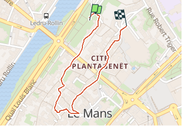
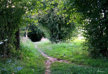
Trail Horseback riding of 874 m to be discovered at Pays de la Loire, Sarthe, Le Mans. This trail is proposed by boubamin.

Elevation profile

Photos

Positioning

Country:
France
Region :
Pays de la Loire
Department/Province :
Sarthe
Municipality :
Le Mans
Location:
Unknown
Start:(UTM)
290941 ; 5321219 (31U) N.

Trails nearby

Trail Mountain bike Changé - Boucle Le Mans - Changé - Brettes - Parigné - Challes 53 km - Photo
Mountain bike
tracegps

Mountain bike

Medium
(2)
Changé, Pays de la Loire, Sarthe, France
53 km | 60 km-effort
2h 30min
No
Trail On foot Rouillon - Chemin Jaune - Photo
On foot
GUIDE+

On foot

Easy
Rouillon, Pays de la Loire, Sarthe, France
3.8 km | 4.4 km-effort
59min
Yes
Trail Walking Le Mans - Le Mans, randonnée autour et dans la ville - Photo
Walking
guydu41

Walking

Easy
Le Mans, Pays de la Loire, Sarthe, France
23 km | 26 km-effort
10h 57min
Yes
Trail Walking Le Mans - Arche de la nature  - Photo
Walking
mallovon

Walking

Easy
Le Mans, Pays de la Loire, Sarthe, France
5.4 km | 6 km-effort
45min
Yes
Trail Mountain bike Coulaines - 34 km coulaines - Photo
Mountain bike
bravunavo

Mountain bike

Medium
(1)
Coulaines, Pays de la Loire, Sarthe, France
34 km | 40 km-effort
Unknown
Yes
Trail Walking Coulaines - Ville et Nature - Coulaines - Photo
Walking
tracegps

Walking

Medium
Coulaines, Pays de la Loire, Sarthe, France
10.2 km | 11.9 km-effort
2h 30min
Yes
Trail Walking Sargé-lès-le-Mans - sarge  - Photo
Walking
patmess

Walking

Medium
Sargé-lès-le-Mans, Pays de la Loire, Sarthe, France
5.7 km | 6.6 km-effort
1h 43min
Yes
Trail Walking Yvré-l'Évêque - le Verger - Photo
Walking
donda

Walking

Very easy
Yvré-l'Évêque, Pays de la Loire, Sarthe, France
8 km | 9.4 km-effort
2h 18min
Yes
Trail Walking Allonnes - Moulin de Chaoué - Photo
Walking
donda

Walking

Very easy
Allonnes, Pays de la Loire, Sarthe, France
9.1 km | 10.3 km-effort
2h 27min
Yes


Close
My subscriptions