Trail Walking Mandres-les-Roses - J 26 Mandres, Boussy , Brunoy le chemin des fresques  - Photo

J 26 Mandres, Boussy , Brunoy le chemin des fresques

Club randonnées SERVON

© OpenStreetMap contributors
Length
Length
12.2 km
Max alt
Max alt
95 m
Uphill gradient
Uphill gradient
121 m
Km-Effort
Km-Effort  
13.8 km
Min alt
Min alt
41 m
Downhill gradient
Downhill gradient
121 m
Boucle
Boucle
Yes
Creation date :
2021-03-15 15:43:22.202
Updated on :
2023-11-08 16:40:12.697

(2 Reviews)

Walking
Walking
3h07
Difficulty : Medium

Scan this QR Code to open this trail in the SityTrail application

FREE GPS app for hiking

Logo SityTrail SityTrail

IGN / Geographical institutes

Download SityTrail from the App Store Download SityTrail from Google Play

Logo SityTrail SityTrail World

The world is yours!

Download SityTrail from the App Store Download SityTrail from Google Play Download SityTrail on Huawei AppGallery

About

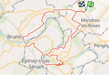
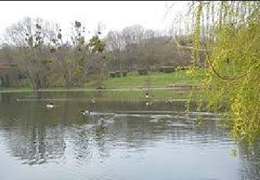
Trail Walking of 12.2 km to be discovered at Ile-de-France, Val-de-Marne, Mandres-les-Roses. This trail is proposed by Les 1000 pattes.

Description

Parking Rue Auguste Dupin, perpendiculaire à la D253 à Mandres près de la zone industrielle , à côté du cimetière
Randonnée "Arts" 3 fresques (2 à Brunoy, 1 à Boussy St Antoine) de l'équipe de graffeurs ARM Crew
Trajet Servon--> Mandres: 5km (10 mn)

Elevation profile

Photos

Positioning

Country:
France
Region :
Ile-de-France
Department/Province :
Val-de-Marne
Municipality :
Mandres-les-Roses
Location:
Unknown
Start:(UTM)
466494 ; 5395061 (31U) N.

Comments

Please log in to post a review or rate the element


Trails nearby

Trail Walking Boussy-Saint-Antoine - GRP CV-IDF 04 - Photo
Walking
clalaur

Walking

Difficult
(1)
Boussy-Saint-Antoine, Ile-de-France, Essonne, France
16.8 km | 18.6 km-effort
4h 13min
No
Trail Walking Marolles-en-Brie - GRP CV-IDF 05 - Photo
Walking
clalaur

Walking

Difficult
(1)
Marolles-en-Brie, Ile-de-France, Val-de-Marne, France
13.5 km | 15.2 km-effort
3h 27min
No
Trail On foot Servon - J 01  11.97 km  les 5 châteaux  - Photo
On foot

On foot

Medium
(1)
Servon, Ile-de-France, Seine-et-Marne, France
11.7 km | 13.2 km-effort
3h 3min
Yes
Trail On foot Servon - R 04 - 8 km -  Servon, Santeny, Servon - Photo
On foot

On foot

Very difficult
(4)
Servon, Ile-de-France, Seine-et-Marne, France
7.9 km | 9.1 km-effort
2h 3min
Yes
Trail Walking Brie-Comte-Robert - brie comte robert - Photo
Walking
Bernardroland

Walking

Easy
(2)
Brie-Comte-Robert, Ile-de-France, Seine-et-Marne, France
16.7 km | 18.8 km-effort
4h 21min
Yes
Trail Walking Yerres - BM Foret Regionale de Grobois 10km - Photo
Walking
GUIDE
jeanmarcMasson

Walking

Medium
(1)
Yerres, Ile-de-France, Essonne, France
10.4 km | 11 km-effort
2h 30min
Yes
Trail Walking Yerres - BM Foret Regionale Grosbois 10km - Photo
Walking
GUIDE
jeanmarcMasson

Walking

Medium
(1)
Yerres, Ile-de-France, Essonne, France
9.8 km | 10.5 km-effort
2h 23min
Yes
Trail On foot Brunoy - L 39 Brunoy, les bords de l'Yerres - Photo
On foot

On foot

Very easy
(4)
Brunoy, Ile-de-France, Essonne, France
5.4 km | 6.1 km-effort
1h 49min
Yes
Trail On foot Quincy-sous-Sénart - J 77 Tigery, Allée Royale - Photo
On foot

On foot

Medium
(2)
Quincy-sous-Sénart, Ile-de-France, Essonne, France
10.6 km | 12 km-effort
2h 44min
Yes


Close
My subscriptions