Trail Walking Yerres - BM Foret Regionale Grosbois 10km - Photo

BM Foret Regionale Grosbois 10km

 jeanmarcMasson
jeanmarcMasson

User GUIDE

© OpenStreetMap contributors
Length
Length
9.8 km
Max alt
Max alt
101 m
Uphill gradient
Uphill gradient
48 m
Km-Effort
Km-Effort  
10.5 km
Min alt
Min alt
87 m
Downhill gradient
Downhill gradient
49 m
Boucle
Boucle
Yes
Creation date :
2023-01-07 07:22:27.867
Updated on :
2023-01-07 07:46:28.179

(1 Reviews)

Walking
Walking
2h23
Difficulty : Medium

Scan this QR Code to open this trail in the SityTrail application

FREE GPS app for hiking

Logo SityTrail SityTrail

IGN / Geographical institutes

Download SityTrail from the App Store Download SityTrail from Google Play

Logo SityTrail SityTrail World

The world is yours!

Download SityTrail from the App Store Download SityTrail from Google Play Download SityTrail on Huawei AppGallery

About

Trail Walking of 9.8 km to be discovered at Ile-de-France, Essonne, Yerres. This trail is proposed by jeanmarcMasson.

Description

Départ et arrivée : parking de la biche au bois

Elevation profile

Positioning

Country:
France
Region :
Ile-de-France
Department/Province :
Essonne
Municipality :
Yerres
Location:
Unknown
Start:(UTM)
463889 ; 5397849 (31U) N.

Comments

Please log in to post a review or rate the element


Trails nearby

Trail Walking Marolles-en-Brie - GRP CV-IDF 05 - Photo
Walking
clalaur

Walking

Difficult
(1)
Marolles-en-Brie, Ile-de-France, Val-de-Marne, France
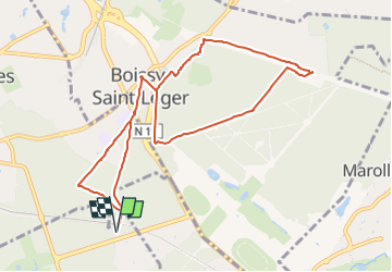
13.5 km | 15.2 km-effort
3h 27min
No
Trail Walking Mandres-les-Roses - J 26 Mandres, Boussy , Brunoy le chemin des fresques  - Photo
Walking

Walking

Medium
(2)
Mandres-les-Roses, Ile-de-France, Val-de-Marne, France
12.2 km | 13.8 km-effort
3h 7min
Yes
Trail Walking Yerres - BM Foret Regionale de Grobois 10km - Photo
Walking
GUIDE
jeanmarcMasson

Walking

Medium
(1)
Yerres, Ile-de-France, Essonne, France
10.4 km | 11 km-effort
2h 30min
Yes
Trail On foot Brunoy - L 39 Brunoy, les bords de l'Yerres - Photo
On foot

On foot

Very easy
(4)
Brunoy, Ile-de-France, Essonne, France
5.4 km | 6.1 km-effort
1h 49min
Yes
Trail On foot Boussy-Saint-Antoine - L 32: Boussy St Antoine l'Yerres et le Gord - Photo
On foot

On foot

Very easy
(3)
Boussy-Saint-Antoine, Ile-de-France, Essonne, France
6.2 km | 7.2 km-effort
1h 38min
Yes
Trail Walking Yerres - J 43  Yerres Parc Caillebotte, île des Prévôts - Photo
Walking

Walking

Medium
(2)
Yerres, Ile-de-France, Essonne, France
11.4 km | 13.1 km-effort
2h 59min
Yes
Trail Walking Marolles-en-Brie - Balade en forêt Domaniale Notre Dame - Photo
Walking
caro94

Walking

Easy
(1)
Marolles-en-Brie, Ile-de-France, Val-de-Marne, France
8.6 km | 9.3 km-effort
2h 3min
Yes
Trail Walking Santeny - SityTrail - R 50 8,0 km - Bois Notre Dame Carrefour du Dauphin - Photo
Walking

Walking

Very difficult
(1)
Santeny, Ile-de-France, Val-de-Marne, France
8.2 km | 8.8 km-effort
1h 30min
Yes
Trail Walking Boissy-Saint-Léger - Boissy - Parc Sucy - 15 km - Photo
Walking
GUIDE
jeanmarcMasson

Walking

Difficult
(1)
Boissy-Saint-Léger, Ile-de-France, Val-de-Marne, France
15 km | 16.7 km-effort
3h 48min
Yes


Close
My subscriptions