


Rando_vtt_Robinson_des_sables_Chepniers

topolino
User
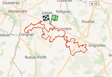

Length
55 km

Max alt
132 m

Uphill gradient
518 m
Km-Effort
62 km

Min alt
65 m

Downhill gradient
517 m
Boucle
Yes
Creation date :
2021-03-17 17:05:02.863
Updated on :
2021-03-17 17:06:28.491
--
Difficulty : Difficult

FREE GPS app for hiking
 SityTrail
IGN / Geographical institutes
SityTrail Plus
The world is yours!
About
Trail Mountain bike of 55 km to be discovered at New Aquitaine, Charente-Maritime, Chepniers. This trail is proposed by topolino.
Positioning
Country:
France
Region :
New Aquitaine
Department/Province :
Charente-Maritime
Municipality :
Chepniers
Location:
Unknown
Start:(Dec)
Start:(UTM)
708946 ; 5015716 (30T) N.
Comments