Trail Walking Montfuron - Montfuron vers Villemus - Photo
 liocol
liocol

User

© OpenStreetMap contributors
Length
Length
4.5 km
Max alt
Max alt
676 m
Uphill gradient
Uphill gradient
121 m
Km-Effort
Km-Effort  
6.1 km
Min alt
Min alt
566 m
Downhill gradient
Downhill gradient
121 m
Boucle
Boucle
Yes
Creation date :
2021-03-21 08:58:29.574
Updated on :
2021-03-21 16:35:59.195

(0 Reviews)

Walking
Walking
1h43
Difficulty : Easy

Scan this QR Code to open this trail in the SityTrail application

FREE GPS app for hiking

Logo SityTrail SityTrail

IGN / Geographical institutes

Download SityTrail from the App Store Download SityTrail from Google Play

Logo SityTrail SityTrail World

The world is yours!

Download SityTrail from the App Store Download SityTrail from Google Play Download SityTrail on Huawei AppGallery

About

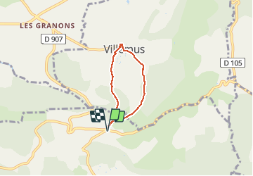
Trail Walking of 4.5 km to be discovered at Provence-Alpes-Côte d'Azur, Alpes-de-Haute-Provence, Montfuron. This trail is proposed by liocol.

Description

Garez vous au carrefour de Montfuron, sur la route d'Apt.
Boucle vers Villemus, visitez le village et montez jusque l'église, jolies vues.

Elevation profile

Photos

Positioning

Country:
France
Region :
Provence-Alpes-Côte d'Azur
Department/Province :
Alpes-de-Haute-Provence
Municipality :
Montfuron
Location:
Unknown
Start:(UTM)
716827 ; 4858092 (31T) N.

Trails nearby

Trail Walking La Bastide-des-Jourdans - Les Collets du Luberon Est - Photo
Walking
ALAPETITE

Walking

Medium
(1)
La Bastide-des-Jourdans, Provence-Alpes-Côte d'Azur, Vaucluse, France
17.9 km | 26 km-effort
5h 50min
Yes
Trail Walking Reillanne - 2024-03-01 Tour de Reillanne  - Photo
Walking
GUIDE
Kargil

Walking

Difficult
Reillanne, Provence-Alpes-Côte d'Azur, Alpes-de-Haute-Provence, France
17.9 km | 24 km-effort
5h 30min
Yes
Trail Walking Saint-Martin-les-Eaux - 1Domaine de Bourne - Photo
Walking
liocol

Walking

Medium
Saint-Martin-les-Eaux, Provence-Alpes-Côte d'Azur, Alpes-de-Haute-Provence, France
5.6 km | 8.3 km-effort
2h 2min
Yes
Trail Walking Montfuron - 1Montfuron, Villemus via la Colle et le Moulin. - Photo
Walking
liocol

Walking

Easy
Montfuron, Provence-Alpes-Côte d'Azur, Alpes-de-Haute-Provence, France
7.6 km | 9.9 km-effort
2h 4min
Yes
Trail Walking Manosque - 1La maison bleue, source de Bourne et dalle aux empreintes - Photo
Walking
liocol

Walking

Medium
Manosque, Provence-Alpes-Côte d'Azur, Alpes-de-Haute-Provence, France
7.4 km | 11.2 km-effort
2h 30min
Yes
Trail Walking Montfuron - 1Montfuron, le relais de Villemus - Photo
Walking
liocol

Walking

Medium
Montfuron, Provence-Alpes-Côte d'Azur, Alpes-de-Haute-Provence, France
8 km | 11.2 km-effort
2h 9min
Yes
Trail Walking Montfuron - Montfuron à Villemus, variante.  - Photo
Walking
liocol

Walking

Easy
(2)
Montfuron, Provence-Alpes-Côte d'Azur, Alpes-de-Haute-Provence, France
7.6 km | 9.8 km-effort
2h 3min
Yes
Trail Walking Pierrevert - 2Pierrevert, la petite gardette - Photo
Walking
liocol

Walking

Easy
Pierrevert, Provence-Alpes-Côte d'Azur, Alpes-de-Haute-Provence, France
8.1 km | 10.3 km-effort
2h 17min
Yes
Trail Walking Montfuron - 1Montjustin - Photo
Walking
liocol

Walking

Medium
Montfuron, Provence-Alpes-Côte d'Azur, Alpes-de-Haute-Provence, France
9.1 km | 12 km-effort
2h 35min
Yes


Close
My subscriptions