Trail Walking Boule-d'Amont - 20210321 Boule d’Amont - Serrabone - Photo

20210321 Boule d’Amont - Serrabone

 ThonyM
ThonyM

User

© OpenStreetMap contributors
Length
Length
13.4 km
Max alt
Max alt
1026 m
Uphill gradient
Uphill gradient
743 m
Km-Effort
Km-Effort  
23 km
Min alt
Min alt
420 m
Downhill gradient
Downhill gradient
747 m
Boucle
Boucle
Yes
Creation date :
2021-03-21 08:17:04.0
Updated on :
2021-03-21 13:05:00.065

(0 Reviews)

Walking
Walking
3h58
Difficulty : Medium

Scan this QR Code to open this trail in the SityTrail application

FREE GPS app for hiking

Logo SityTrail SityTrail

IGN / Geographical institutes

Download SityTrail from the App Store Download SityTrail from Google Play

Logo SityTrail SityTrail World

The world is yours!

Download SityTrail from the App Store Download SityTrail from Google Play Download SityTrail on Huawei AppGallery

About

Trail Walking of 13.4 km to be discovered at Occitania, Pyrénées-Orientales, Boule-d'Amont. This trail is proposed by ThonyM.

Description

Quelques petites ascensions bines pour les jambes ...

Elevation profile

Photos

Positioning

Country:
France
Region :
Occitania
Department/Province :
Pyrénées-Orientales
Municipality :
Boule-d'Amont
Location:
Unknown
Start:(UTM)
468322 ; 4714221 (31T) N.

Trails nearby

Trail Walking Prunet-et-Belpuig - Boule d’amont /Chapelle de la Trinité / Prunet  - Photo
Walking
robertperello

Walking

Easy
Prunet-et-Belpuig, Occitania, Pyrénées-Orientales, France
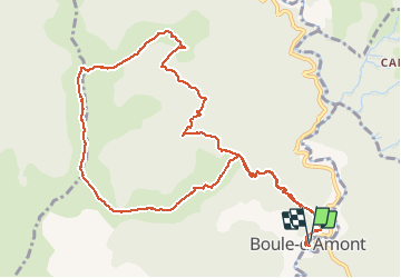
11.2 km | 16 km-effort
3h 6min
Yes
Trail Walking Boule-d'Amont - 20240104 Tour depuis le prieuré de Serrabonne  - Photo
Walking
ThonyM

Walking

Medium
Boule-d'Amont, Occitania, Pyrénées-Orientales, France
15.2 km | 26 km-effort
4h 37min
Yes
Trail Walking Boule-d'Amont - Serrabone /le roc rouge(le rocher du dragon):itinéraire 2 - Photo
Walking
robertperello

Walking

Medium
Boule-d'Amont, Occitania, Pyrénées-Orientales, France
10.1 km | 17.5 km-effort
3h 32min
Yes
Trail Walking Boule-d'Amont - Serra une - Photo
Walking
ombrabella

Walking

Medium
Boule-d'Amont, Occitania, Pyrénées-Orientales, France
10.4 km | 17.8 km-effort
3h 44min
Yes
Trail Walking Boule-d'Amont - Serrabonne autour du prieuré  - Photo
Walking
MarieFrancoise

Walking

Medium
Boule-d'Amont, Occitania, Pyrénées-Orientales, France
9.3 km | 16.2 km-effort
4h 27min
Yes
Trail Walking Caixas - Fontcouverte 3 chapelles - Photo
Walking
robertperello

Walking

Difficult
Caixas, Occitania, Pyrénées-Orientales, France
28 km | 38 km-effort
3h 46min
No
Trail Walking Prunet-et-Belpuig - Boule d’amont Prunet-et-Belpuig la Trinité  - Photo
Walking
robertperello

Walking

Difficult
Prunet-et-Belpuig, Occitania, Pyrénées-Orientales, France
13.7 km | 19.4 km-effort
3h 25min
Yes
Trail Walking La Bastide - La Bastide-Palomere-StMarsal - Photo
Walking
ThonyM

Walking

Very difficult
La Bastide, Occitania, Pyrénées-Orientales, France
19.8 km | 31 km-effort
6h 51min
Yes
Trail Walking Casefabre - Col de l’oratoire églises St Pons, fontcouverte, Sté - Photo
Walking
ThonyM

Walking

Very difficult
Casefabre, Occitania, Pyrénées-Orientales, France
21 km | 28 km-effort
6h 19min
Yes


Close
My subscriptions