


guebwiller

gerard70
User
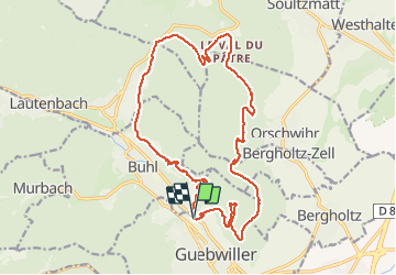

Length
19.5 km

Max alt
566 m

Uphill gradient
713 m
Km-Effort
29 km

Min alt
308 m

Downhill gradient
711 m
Boucle
Yes
Creation date :
2021-03-23 07:54:16.679
Updated on :
2021-03-23 15:54:56.604
7h12
Difficulty : Medium

FREE GPS app for hiking
 SityTrail
IGN / Geographical institutes
SityTrail Plus
The world is yours!
About
Trail Walking of 19.5 km to be discovered at Grand Est, Haut-Rhin, Guebwiller. This trail is proposed by gerard70.
Positioning
Country:
France
Region :
Grand Est
Department/Province :
Haut-Rhin
Municipality :
Guebwiller
Location:
Unknown
Start:(Dec)
Start:(UTM)
365852 ; 5308647 (32T) N.
Comments