


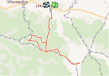
parking+ baigura +adarre complet +retour p

Patox
User

Length
10.3 km

Max alt
879 m

Uphill gradient
907 m
Km-Effort
22 km

Min alt
171 m

Downhill gradient
907 m
Boucle
Yes
Creation date :
2021-03-24 12:55:14.98
Updated on :
2021-03-24 15:49:19.14
2h43
Difficulty : Very easy

FREE GPS app for hiking
 SityTrail
IGN / Geographical institutes
SityTrail Plus
The world is yours!
About
Trail Trail of 10.3 km to be discovered at New Aquitaine, Pyrénées-Atlantiques, Macaye. This trail is proposed by Patox.
Positioning
Country:
France
Region :
New Aquitaine
Department/Province :
Pyrénées-Atlantiques
Municipality :
Macaye
Location:
Unknown
Start:(Dec)
Start:(UTM)
636983 ; 4796771 (30T) N.
Comments