Trail Walking Aydius - Randonnee-Mardas-Iseye-Mariano-le-20-08-2011 - Photo

Randonnee-Mardas-Iseye-Mariano-le-20-08-2011

© OpenStreetMap contributors
Length
Length
10.3 km
Max alt
Max alt
2163 m
Uphill gradient
Uphill gradient
1080 m
Km-Effort
Km-Effort  
25 km
Min alt
Min alt
1090 m
Downhill gradient
Downhill gradient
1080 m
Boucle
Boucle
Yes
Creation date :
2021-03-25 17:22:29.638
Updated on :
2021-03-25 17:25:32.16

(0 Reviews)

Walking
Walking
5h30
Difficulty : Difficult

Scan this QR Code to open this trail in the SityTrail application

FREE GPS app for hiking

Logo SityTrail SityTrail

IGN / Geographical institutes

Download SityTrail from the App Store Download SityTrail from Google Play

Logo SityTrail SityTrail World

The world is yours!

Download SityTrail from the App Store Download SityTrail from Google Play Download SityTrail on Huawei AppGallery

About

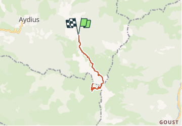
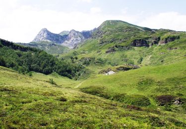
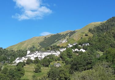
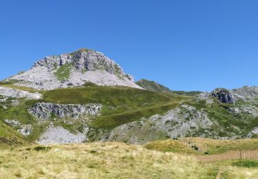
Trail Walking of 10.3 km to be discovered at New Aquitaine, Pyrénées-Atlantiques, Aydius. This trail is proposed by neoroll44.

Description

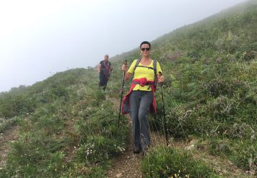
Depuis le village d’Aydius suivre la piste pendant 6,5km , les 3 derniers kilomètres se font sur une piste carrossable en bon état. Altitude 1060m, un cairn au bord de la piste vous indique le départ de la randonnée. Suivre le sentier rentrant dans le bois (plein Sud)

Attention: La piste qui était autorisée ces dernières années est de nouveau soumise à une réglementation: l’accès au parking final en voiture, après la piste carrossable, est autorisé seulement avant 9h du matin, l’amende de 5ème classe peut aller jusqu’à 1500€ ! ! ! dans le doute renseignez-vous à la mairie.

Elevation profile

Photos

Points of interest

Point of interest Aydius - Col-Taillandère-1836m - Photo
neoroll44
Point of interest Aydius - Crête de Barca - Photo
neoroll44
Point of interest Accous - Lac-Montagnon-2003m - Photo
neoroll44
Point of interest Aydius - L'Arigalos (Ruisseau) - Photo
neoroll44
Point of interest Laruns - L'Escala - Photo
neoroll44
LARUNS 
Point of interest Accous - Montagnon-D-Iseye-2173m - Photo
neoroll44
Point of interest Accous - Pic-Mardas-2188m - Photo
neoroll44

Positioning

Country:
France
Region :
New Aquitaine
Department/Province :
Pyrénées-Atlantiques
Municipality :
Aydius
Location:
Unknown
Start:(UTM)
703135 ; 4763131 (30T) N.

Trails nearby

Trail Walking Bielle - Pics de Cambeilh et petit Gerbe  - Photo
Walking
DuMarsan

Walking

Easy
(1)
Bielle, New Aquitaine, Pyrénées-Atlantiques, France
13.7 km | 27 km-effort
5h 24min
Yes
Trail On foot Aydius - Tour du Mailh Massibé par Bésur asp100 - Photo
On foot
PRO

On foot

Medium
Aydius, New Aquitaine, Pyrénées-Atlantiques, France
9.8 km | 23 km-effort
5h 7min
No
Trail On foot Aydius - Chemin des Buis de Camploung asp22 - Photo
On foot
PRO

On foot

Easy
Aydius, New Aquitaine, Pyrénées-Atlantiques, France
4.1 km | 6.3 km-effort
1h 26min
Yes
Trail On foot Aydius - Col de Bergout par les Ichantes asp23 - Photo
On foot
PRO

On foot

Easy
Aydius, New Aquitaine, Pyrénées-Atlantiques, France
6.8 km | 14.1 km-effort
3h 12min
No
Trail Walking Aydius - lac de montagnon - Photo
Walking
bedous

Walking

Very difficult
Aydius, New Aquitaine, Pyrénées-Atlantiques, France
12.8 km | 28 km-effort
6h 45min
Yes
Trail On foot Aydius - du Barca à la Cabane d'Arriutort asp106 - Photo
On foot
PRO

On foot

Easy
Aydius, New Aquitaine, Pyrénées-Atlantiques, France
6.4 km | 14.1 km-effort
3h 12min
No
Trail Walking Aydius - 021 Tour_Igaut-Chechit ab - Photo
Walking
bedous

Walking

Easy
(1)
Aydius, New Aquitaine, Pyrénées-Atlantiques, France
3.3 km | 5.2 km-effort
1h 4min
Yes
Trail Walking Accous - Cabane du Bergout - Photo
Walking
alfreson

Walking

Medium
Accous, New Aquitaine, Pyrénées-Atlantiques, France
4 km | 7.8 km-effort
1h 35min
Yes
Trail Walking Aydius - pic mailh massibe et pic montagnon - Photo
Walking
PVERTICAL

Walking

Medium
Aydius, New Aquitaine, Pyrénées-Atlantiques, France
12.8 km | 31 km-effort
7h 18min
No


Close
My subscriptions