


colmar

jcschubnel
User
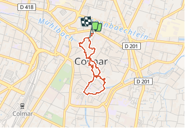

Length
2.9 km

Max alt
201 m

Uphill gradient
19 m
Km-Effort
3.2 km

Min alt
188 m

Downhill gradient
18 m
Boucle
Yes
Creation date :
2021-03-27 13:52:08.377
Updated on :
2021-03-27 15:59:51.026
2h01
Difficulty : Very easy

FREE GPS app for hiking
 SityTrail
IGN / Geographical institutes
SityTrail Plus
The world is yours!
About
Trail Walking of 2.9 km to be discovered at Grand Est, Haut-Rhin, Colmar. This trail is proposed by jcschubnel.
Positioning
Country:
France
Region :
Grand Est
Department/Province :
Haut-Rhin
Municipality :
Colmar
Location:
Unknown
Start:(Dec)
Start:(UTM)
377683 ; 5326531 (32U) N.
Comments