


Fréland - Chalet de l'Etoile

duchaine.nicolas
User
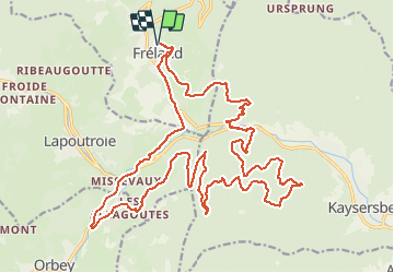

Length
27 km

Max alt
638 m

Uphill gradient
972 m
Km-Effort
40 km

Min alt
316 m

Downhill gradient
971 m
Boucle
Yes
Creation date :
2021-03-27 16:22:01.093
Updated on :
2021-04-11 12:28:09.664
1h45
Difficulty : Very easy
1h45
Difficulty : Very easy

FREE GPS app for hiking
 SityTrail
IGN / Geographical institutes
SityTrail Plus
The world is yours!
About
Trail Mountain bike of 27 km to be discovered at Grand Est, Haut-Rhin, Fréland. This trail is proposed by duchaine.nicolas.
Description
retour via les Allagouttes
Positioning
Country:
France
Region :
Grand Est
Department/Province :
Haut-Rhin
Municipality :
Fréland
Location:
Unknown
Start:(Dec)
Start:(UTM)
365797 ; 5337179 (32U) N.
Comments