Trail Mountain bike Mauvezin - La Gimone - Sarrant - Photo

La Gimone - Sarrant

© OpenStreetMap contributors
Length
Length
25 km
Max alt
Max alt
181 m
Uphill gradient
Uphill gradient
268 m
Km-Effort
Km-Effort  
29 km
Min alt
Min alt
114 m
Downhill gradient
Downhill gradient
268 m
Boucle
Boucle
Yes
Creation date :
2021-03-28 08:19:12.0
Updated on :
2021-03-28 10:44:49.486

(0 Reviews)

Mountain bike
Mountain bike
2h24
Difficulty : Easy

Scan this QR Code to open this trail in the SityTrail application

FREE GPS app for hiking

Logo SityTrail SityTrail

IGN / Geographical institutes

Download SityTrail from the App Store Download SityTrail from Google Play

Logo SityTrail SityTrail World

The world is yours!

Download SityTrail from the App Store Download SityTrail from Google Play Download SityTrail on Huawei AppGallery

About

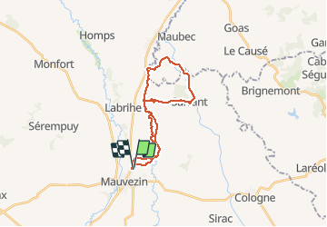
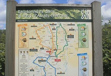
Trail Mountain bike of 25 km to be discovered at Occitania, Gers, Mauvezin. This trail is proposed by lorenzot54.

Description

Départ balisage vtt, Longer la Gimone, château de Savaillan et son pigeonnier a 5 arches, chemin des pigeonniers, village médiéval de Sarrant (en rénovation), gite de Noua puis retour par-là vallée de la Gimone.

Elevation profile

Positioning

Country:
France
Region :
Occitania
Department/Province :
Gers
Municipality :
Mauvezin
Location:
Unknown
Start:(UTM)
329768 ; 4844916 (31T) N.

Trails nearby

Trail On foot Mauvezin - Wikiloc - Mauvezin Le Gouffre de La Hobio - Photo
On foot
jeromelacoste

On foot

Easy
(1)
Mauvezin, Occitania, Gers, France
15.1 km | 18.8 km-effort
Unknown
Yes
Trail Running Mauvezin - Ronde des foies gras - Mauvezin - Photo
Running
tracegps

Running

Difficult
Mauvezin, Occitania, Gers, France
25 km | 29 km-effort
3h 0min
No
Trail Mountain bike Mauvezin - Ronde des foies gras - Mauvezin - Photo
Mountain bike
tracegps

Mountain bike

Medium
Mauvezin, Occitania, Gers, France
25 km | 29 km-effort
2h 0min
No
Trail On foot Mauvezin - Circuit des Jonquilles - Photo
On foot
jeromelacoste

On foot

Easy
Mauvezin, Occitania, Gers, France
13.4 km | 15.3 km-effort
3h 15min
Yes
Trail Mountain bike Mauvezin - Solomiac-Maubec - Photo
Mountain bike
lorenzot54

Mountain bike

Mauvezin, Occitania, Gers, France
29 km | 34 km-effort
1h 51min
Yes
Trail Walking Mauvezin - Tour de Mauvezin - Photo
Walking
lorenzot54

Walking

Mauvezin, Occitania, Gers, France
4.3 km | 5.2 km-effort
1h 20min
Yes
Trail Walking Saint-Antonin - Marie vers Saint sauvy - Photo
Walking
yves31

Walking

Very easy
Saint-Antonin, Occitania, Gers, France
5.8 km | 6.7 km-effort
1h 28min
No
Trail Mountain bike Mauvezin - Randonnée VTT - Mauvezin - Photo
Mountain bike
tracegps

Mountain bike

Medium
Mauvezin, Occitania, Gers, France
15.5 km | 18.3 km-effort
1h 10min
Yes
Trail Walking Sarrant - Sarrant Les Pigeonniers - Photo
Walking
TonioNantes

Walking

Medium
Sarrant, Occitania, Gers, France
8.1 km | 9.9 km-effort
3h 0min
Yes


Close
My subscriptions