


Lac de Kruth

Christian Arnold
User

Length
22 km

Max alt
578 m

Uphill gradient
322 m
Km-Effort
26 km

Min alt
435 m

Downhill gradient
309 m
Boucle
Yes
Creation date :
2021-03-28 09:57:20.0
Updated on :
2021-03-28 13:03:14.018
1h57
Difficulty : Medium

FREE GPS app for hiking
 SityTrail
IGN / Geographical institutes
SityTrail Plus
The world is yours!
About
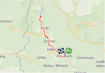
Trail Mountain bike of 22 km to be discovered at Grand Est, Haut-Rhin, Ranspach. This trail is proposed by Christian Arnold.
Positioning
Country:
France
Region :
Grand Est
Department/Province :
Haut-Rhin
Municipality :
Ranspach
Location:
Unknown
Start:(Dec)
Start:(UTM)
351391 ; 5305333 (32T) N.
Comments