


Retour Tour de mir

Phidel66
User
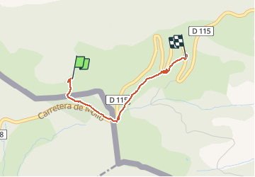

Length
2.2 km

Max alt
1535 m

Uphill gradient
27 m
Km-Effort
2.9 km

Min alt
1391 m

Downhill gradient
136 m
Boucle
No
Creation date :
2021-03-30 14:29:05.243
Updated on :
2021-03-30 15:29:54.982
1h00
Difficulty : Very easy

FREE GPS app for hiking
 SityTrail
IGN / Geographical institutes
SityTrail Plus
The world is yours!
About
Trail Walking of 2.2 km to be discovered at Occitania, Pyrénées-Orientales, Prats-de-Mollo-la-Preste. This trail is proposed by Phidel66.
Description
romarin
Positioning
Country:
France
Region :
Occitania
Department/Province :
Pyrénées-Orientales
Municipality :
Prats-de-Mollo-la-Preste
Location:
Unknown
Start:(Dec)
Start:(UTM)
454832 ; 4691103 (31T) N.
Comments