


JFT YB Etape6 02-05-2014

jeff2
User

Length
35 km

Max alt
153 m

Uphill gradient
378 m
Km-Effort
39 km

Min alt
74 m

Downhill gradient
329 m
Boucle
No
Creation date :
2014-12-10 00:00:00.0
Updated on :
2014-12-10 00:00:00.0
7h41
Difficulty : Easy

FREE GPS app for hiking
 SityTrail
IGN / Geographical institutes
SityTrail Plus
The world is yours!
About
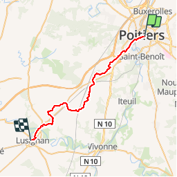
Trail Walking of 35 km to be discovered at New Aquitaine, Vienne, Poitiers. This trail is proposed by jeff2.
Description
Poitiers lusignan
Photos


Positioning
Country:
France
Region :
New Aquitaine
Department/Province :
Vienne
Municipality :
Poitiers
Location:
Unknown
Start:(Dec)
Start:(UTM)
296681 ; 5161717 (31T) N.
Comments