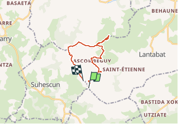
Hocha Handia

FERREREMARC
User

Length
11.7 km

Max alt
564 m

Uphill gradient
584 m
Km-Effort
19.3 km

Min alt
210 m

Downhill gradient
504 m
Boucle
No
Creation date :
2021-04-01 07:39:11.023
Updated on :
2021-04-01 13:39:04.975
3h40
Difficulty : Very difficult

FREE GPS app for hiking
 SityTrail
IGN / Geographical institutes
SityTrail Plus
The world is yours!
About
Trail Walking of 11.7 km to be discovered at New Aquitaine, Pyrénées-Atlantiques, Lantabat. This trail is proposed by FERREREMARC.
Positioning
Country:
France
Region :
New Aquitaine
Department/Province :
Pyrénées-Atlantiques
Municipality :
Lantabat
Location:
Unknown
Start:(Dec)
Start:(UTM)
648792 ; 4788292 (30T) N.
Comments