


Puy gris (presque)

oliviergau
User

Length
14.4 km

Max alt
2479 m

Uphill gradient
1265 m
Km-Effort
31 km

Min alt
1211 m

Downhill gradient
1266 m
Boucle
Yes
Creation date :
2021-04-03 05:52:28.824
Updated on :
2021-04-03 12:24:26.311
3h56
Difficulty : Very easy

FREE GPS app for hiking
 SityTrail
IGN / Geographical institutes
SityTrail Plus
The world is yours!
About
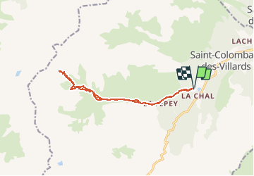
Trail Touring skiing of 14.4 km to be discovered at Auvergne-Rhône-Alpes, Savoy, Saint-Colomban-des-Villards. This trail is proposed by oliviergau.
Positioning
Country:
France
Region :
Auvergne-Rhône-Alpes
Department/Province :
Savoy
Municipality :
Saint-Colomban-des-Villards
Location:
Unknown
Start:(Dec)
Start:(UTM)
281230 ; 5018271 (32T) N.
Comments