


PhD romarins st Estève

Phidel66
User

Length
16.9 km

Max alt
92 m

Uphill gradient
130 m
Km-Effort
18.6 km

Min alt
19 m

Downhill gradient
119 m
Boucle
No
Creation date :
2021-04-02 15:11:58.465
Updated on :
2021-04-08 16:08:50.977
5h04
Difficulty : Difficult

FREE GPS app for hiking
 SityTrail
IGN / Geographical institutes
SityTrail Plus
The world is yours!
About
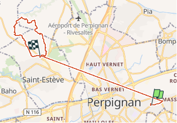
Trail Walking of 16.9 km to be discovered at Occitania, Pyrénées-Orientales, Perpignan. This trail is proposed by Phidel66.
Description
romarin
Positioning
Country:
France
Region :
Occitania
Department/Province :
Pyrénées-Orientales
Municipality :
Perpignan
Location:
Unknown
Start:(Dec)
Start:(UTM)
493575 ; 4727169 (31T) N.
Comments