


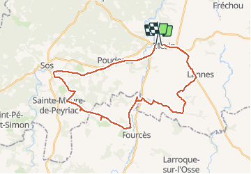
circuit VTT Mezin-voie verte Sos-Ste Maure de Peyriac-Fources-Villeneuve de Mezin-Lannes-Mezin

Forsans
User

Length
36 km

Max alt
170 m

Uphill gradient
454 m
Km-Effort
42 km

Min alt
63 m

Downhill gradient
431 m
Boucle
No
Creation date :
2021-04-08 12:09:32.286
Updated on :
2021-04-08 17:43:31.781
2h27
Difficulty : Easy

FREE GPS app for hiking
 SityTrail
IGN / Geographical institutes
SityTrail Plus
The world is yours!
About
Trail Mountain bike of 36 km to be discovered at New Aquitaine, Lot-et-Garonne, Mézin. This trail is proposed by Forsans.
Description
circuit chemin et route
Positioning
Country:
France
Region :
New Aquitaine
Department/Province :
Lot-et-Garonne
Municipality :
Mézin
Location:
Unknown
Start:(Dec)
Start:(UTM)
279622 ; 4881743 (31T) N.
Comments