


marbach

pascalloos
User

Length
10.4 km

Max alt
541 m

Uphill gradient
365 m
Km-Effort
15.2 km

Min alt
211 m

Downhill gradient
361 m
Boucle
Yes
Creation date :
2021-04-11 08:30:11.268
Updated on :
2021-04-11 12:53:31.438
2h31
Difficulty : Easy

FREE GPS app for hiking
 SityTrail
IGN / Geographical institutes
SityTrail Plus
The world is yours!
About
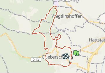
Trail Walking of 10.4 km to be discovered at Grand Est, Haut-Rhin, Gueberschwihr. This trail is proposed by pascalloos.
Description
Gueberschwihr, voegtlinshoffen, marbach couvent st Marc gueberschwihr
Positioning
Country:
France
Region :
Grand Est
Department/Province :
Haut-Rhin
Municipality :
Gueberschwihr
Location:
Unknown
Start:(Dec)
Start:(UTM)
372083 ; 5318070 (32U) N.
Comments