


L'ADARRE

DECHAMPD
User
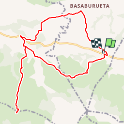

Length
11.9 km

Max alt
450 m

Uphill gradient
573 m
Km-Effort
19.5 km

Min alt
164 m

Downhill gradient
573 m
Boucle
Yes
Creation date :
2019-01-14 17:35:50.424
Updated on :
2019-01-14 17:35:50.458
4h03
Difficulty : Easy

FREE GPS app for hiking
 SityTrail
IGN / Geographical institutes
SityTrail Plus
The world is yours!
About
Trail Walking of 11.9 km to be discovered at New Aquitaine, Pyrénées-Atlantiques, Mendionde. This trail is proposed by DECHAMPD.
Description
Départ de la base de loisirs, jusqu'au col de Chancho sans montée au sommet de l'Adarre, puis retour par le nord et une partie du chemin de Conpostelle


Positioning
Country:
France
Region :
New Aquitaine
Department/Province :
Pyrénées-Atlantiques
Municipality :
Mendionde
Location:
Unknown
Start:(Dec)
Start:(UTM)
639275 ; 4796600 (30T) N.
Comments