


2021 04 Tour du Hartmanswillerkopf

staubalex
User
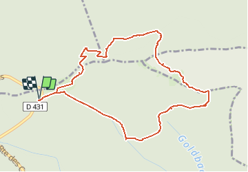

Length
5.1 km

Max alt
930 m

Uphill gradient
245 m
Km-Effort
8.4 km

Min alt
755 m

Downhill gradient
245 m
Boucle
Yes
Creation date :
2021-04-13 11:26:18.427
Updated on :
2021-04-13 11:27:37.093
1h54
Difficulty : Easy

FREE GPS app for hiking
 SityTrail
IGN / Geographical institutes
SityTrail Plus
The world is yours!
About
Trail On foot of 5.1 km to be discovered at Grand Est, Haut-Rhin, Wattwiller. This trail is proposed by staubalex.
Positioning
Country:
France
Region :
Grand Est
Department/Province :
Haut-Rhin
Municipality :
Wattwiller
Location:
Unknown
Start:(Dec)
Start:(UTM)
361509 ; 5302156 (32T) N.
Comments