


Autour de Hochstatt

jmbilger
User
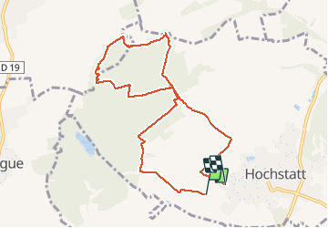

Length
9.1 km

Max alt
331 m

Uphill gradient
134 m
Km-Effort
10.9 km

Min alt
275 m

Downhill gradient
139 m
Boucle
No
Creation date :
2021-04-14 13:02:56.0
Updated on :
2021-04-14 15:27:47.366
2h24
Difficulty : Medium

FREE GPS app for hiking
 SityTrail
IGN / Geographical institutes
SityTrail Plus
The world is yours!
About
Trail Walking of 9.1 km to be discovered at Grand Est, Haut-Rhin, Hochstatt. This trail is proposed by jmbilger.
Positioning
Country:
France
Region :
Grand Est
Department/Province :
Haut-Rhin
Municipality :
Hochstatt
Location:
Unknown
Start:(Dec)
Start:(UTM)
369759 ; 5284481 (32T) N.
Comments