Trail Walking Crozet - CROZET:  balade par la campagne - Photo

CROZET: balade par la campagne

 otgex
otgex

User

© OpenStreetMap contributors
Length
Length
5.2 km
Max alt
Max alt
540 m
Uphill gradient
Uphill gradient
52 m
Km-Effort
Km-Effort  
5.9 km
Min alt
Min alt
495 m
Downhill gradient
Downhill gradient
53 m
Boucle
Boucle
Yes
Creation date :
2014-12-11 00:00:00.0
Updated on :
2014-12-11 00:00:00.0

(0 Reviews)

Walking
Walking
1h00
Difficulty : Unknown

Scan this QR Code to open this trail in the SityTrail application

FREE GPS app for hiking

Logo SityTrail SityTrail

IGN / Geographical institutes

Download SityTrail from the App Store Download SityTrail from Google Play

Logo SityTrail SityTrail World

The world is yours!

Download SityTrail from the App Store Download SityTrail from Google Play Download SityTrail on Huawei AppGallery

About

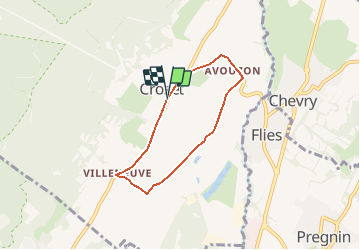
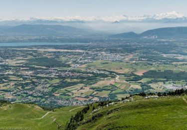
Trail Walking of 5.2 km to be discovered at Auvergne-Rhône-Alpes, Ain, Crozet. This trail is proposed by otgex.

Description

Départ depuis la mairie/école de Crozet (centre du village).
Prenez la route de Villeneuve; entrez dans Villeneuve. Juste avant les ralentisseurs, tournez sur la gauche par le chemin des Nants puis face aux Alpes (le chemin du grand verger). Prenez ensuite à gauche et passez  vers le réservoir, puis à 90° sur la gauche (le chemin des Cutils) en revenant direction Avouzon. Attention, traversée de la départementale . Faites attention aux voitures. Prenez tout  droit en longeant  l''hôtel - restaurant Le Jiva Hill. Suivez le chemin des Grands Reinnets. Vous arrivez sur la Route d''Avouzon par le lotissement  "le Griottier". Passez devant la fontaine et remontez la rue principale en direction de la Mairie de Crozet.

Elevation profile

Positioning

Country:
France
Region :
Auvergne-Rhône-Alpes
Department/Province :
Ain
Municipality :
Crozet
Location:
Unknown
Start:(UTM)
270000 ; 5129429 (32T) N.

Trails nearby

Trail Snowshoes Crozet - Crêt de la Neige - Photo
Snowshoes
simon.paume

Snowshoes

Medium
(2)
Crozet, Auvergne-Rhône-Alpes, Ain, France
6.2 km | 9.9 km-effort
4h 0min
Yes
Trail Walking Crozet - lelex le reculet - Photo
Walking
loca.yves

Walking

Medium
Crozet, Auvergne-Rhône-Alpes, Ain, France
11.4 km | 17.5 km-effort
4h 45min
Yes
Trail Walking Lélex - GR 9 - Étape 9 - Refuge de la Loge - Menthière - Photo
Walking
pcugnod

Walking

Difficult
Lélex, Auvergne-Rhône-Alpes, Ain, France
20 km | 30 km-effort
7h 0min
No
Trail Walking Thoiry - Le Reculet Le Crêt de la Neige - Photo
Walking
dominiq

Walking

Difficult
(1)
Thoiry, Auvergne-Rhône-Alpes, Ain, France
10.7 km | 23 km-effort
4h 39min
Yes
Trail Walking Thoiry - Le Reculet  - Photo
Walking
Arvierie56@Gmail.com

Walking

Difficult
Thoiry, Auvergne-Rhône-Alpes, Ain, France
11.2 km | 26 km-effort
4h 29min
Yes
Trail Walking Échenevex - Sources de l''Allondon - Echenevex - Photo
Walking
tracegps

Walking

Medium
Échenevex, Auvergne-Rhône-Alpes, Ain, France
3.5 km | 4.4 km-effort
2h 0min
Yes
Trail Walking Thoiry - Crêt de la Neige et Reculet - Thoiry - Photo
Walking
tracegps

Walking

Difficult
Thoiry, Auvergne-Rhône-Alpes, Ain, France
10.6 km | 23 km-effort
5h 15min
Yes
Trail Cycle Meyrin - 2012-04-21 11h33m19 - Photo
Cycle
jpvergeres

Cycle

Medium
(1)
Meyrin, Geneva, Unknown, Switzerland
33 km | 39 km-effort
1h 27min
Yes
Trail Running Meyrin - Super Furius - Photo
Running
J-P Ballaman

Running

Easy
Meyrin, Geneva, Unknown, Switzerland
12.6 km | 14.7 km-effort
Unknown
Yes


Close
My subscriptions