Trail Walking Dinant - les cascadelles - Photo

les cascadelles

© OpenStreetMap contributors
Length
Length
7.1 km
Max alt
Max alt
267 m
Uphill gradient
Uphill gradient
213 m
Km-Effort
Km-Effort  
9.9 km
Min alt
Min alt
100 m
Downhill gradient
Downhill gradient
212 m
Boucle
Boucle
Yes
Creation date :
2021-04-18 10:11:02.598
Updated on :
2021-04-18 10:11:02.598

(1 Reviews)

Walking
Walking
--
Difficulty : Unknown

Scan this QR Code to open this trail in the SityTrail application

FREE GPS app for hiking

Logo SityTrail SityTrail

IGN / Geographical institutes

Download SityTrail from the App Store Download SityTrail from Google Play

Logo SityTrail SityTrail World

The world is yours!

Download SityTrail from the App Store Download SityTrail from Google Play Download SityTrail on Huawei AppGallery

About

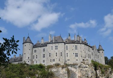
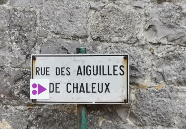
Trail Walking of 7.1 km to be discovered at Wallonia, Namur, Dinant. This trail is proposed by Alain Steinier.

Elevation profile

Points of interest

Point of interest Dinant -  Place Roger Bodard - Photo
Alain Steinier
Point of interest Dinant - Embranchement, à droite - Photo
Alain Steinier
Point of interest Dinant - Croisement, tout droit - Photo
Alain Steinier
Point of interest Hastière - Chemin à gauche - Photo
Alain Steinier
HASTIÈRE 
Point of interest Hastière - Chemin à gauche - Photo
Alain Steinier
HASTIÈRE 
Point of interest Hastière - Prendre à gauche - Photo
Alain Steinier
Point of interest Dinant - Sentier sur la gauche - Photo
Alain Steinier
Point of interest Dinant - À gauche dans la Rue Haute - Photo
Alain Steinier
Point of interest Dinant - À gauche dans la Rue Marette - Photo
Alain Steinier
Point of interest Dinant - Place Roger Bodard - Photo
Alain Steinier

Positioning

Country:
Belgium
Region :
Wallonia
Department/Province :
Namur
Municipality :
Dinant
Location:
Falmignoul
Start:(UTM)
635101 ; 5562967 (31U) N.

Comments

Please log in to post a review or rate the element


Attention sa monte pendant presque toute la ballade et quelques passages sur de la roche


Trails nearby

Trail Walking Dinant - RB-Na-24-Entre Lesse et Meuse - Photo
Walking
PRO

Walking

Very difficult
(14)
Dinant, Wallonia, Namur, Belgium
19.3 km | 26 km-effort
5h 57min
Yes
Trail Walking Hastière - Balade de Hastière à Waulsort - Photo
Walking
GUIDE
Desrumaux

Walking

Medium
(2)
Hastière, Wallonia, Namur, Belgium
10.8 km | 13.8 km-effort
3h 2min
Yes
Trail Walking Dinant - D'Anseremme à Dinant - Photo
Walking
GUIDE
Desrumaux

Walking

Easy
(3)
Dinant, Wallonia, Namur, Belgium
8.3 km | 11.8 km-effort
2h 34min
Yes
Trail Walking Hastière - RB-Na-10 Raccourci 2 - Sur les crêtes mosanes - Photo
Walking
PRO

Walking

Easy
(2)
Hastière, Wallonia, Namur, Belgium
18.1 km | 25 km-effort
4h 29min
Yes
Trail Walking Hastière - RB-Na-10 Raccourci 1 - Sur les crêtes mosanes - Photo
Walking
PRO

Walking

Medium
(3)
Hastière, Wallonia, Namur, Belgium
15.3 km | 21 km-effort
5h 28min
Yes
Trail Walking Hastière - RB-Na-10 - Sur les crêtes mosanes - Photo
Walking
PRO

Walking

Medium
(4)
Hastière, Wallonia, Namur, Belgium
22 km | 29 km-effort
6h 21min
Yes
Trail Walking Dinant - RB-Na-24-racc-Entre Lesse et Meuse - Photo
Walking
PRO

Walking

Very difficult
(4)
Dinant, Wallonia, Namur, Belgium
18.5 km | 24 km-effort
5h 29min
Yes
Trail Walking Dinant - FURFFOZ ... les Aiguilles de Chaleux et la Réserve  naturelle. - Photo
Walking
GerardBouche

Walking

Easy
(6)
Dinant, Wallonia, Namur, Belgium
9.6 km | 12.9 km-effort
1h 38min
Yes
Trail Walking Dinant - ANSEREMME (Passerelle) - Photo
Walking
GerardBouche

Walking

Easy
(4)
Dinant, Wallonia, Namur, Belgium
11.6 km | 15 km-effort
3h 15min
Yes


Close
My subscriptions