


2021 04 18 Peternit

staubalex
User
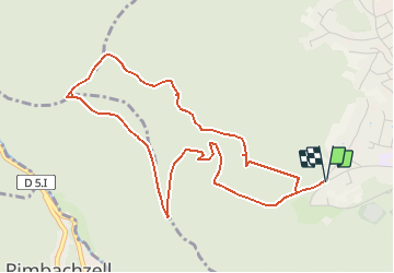

Length
5.1 km

Max alt
629 m

Uphill gradient
265 m
Km-Effort
8.6 km

Min alt
366 m

Downhill gradient
265 m
Boucle
Yes
Creation date :
2021-04-18 13:25:09.073
Updated on :
2021-04-18 13:25:55.811
1h57
Difficulty : Medium

FREE GPS app for hiking
 SityTrail
IGN / Geographical institutes
SityTrail Plus
The world is yours!
About
Trail Walking of 5.1 km to be discovered at Grand Est, Haut-Rhin, Guebwiller. This trail is proposed by staubalex.
Positioning
Country:
France
Region :
Grand Est
Department/Province :
Haut-Rhin
Municipality :
Guebwiller
Location:
Unknown
Start:(Dec)
Start:(UTM)
365288 ; 5307325 (32T) N.
Comments