Trail Walking Saint-Germier - st Germier - Photo
 yvon26
yvon26

User

© OpenStreetMap contributors
Length
Length
3.2 km
Max alt
Max alt
168 m
Uphill gradient
Uphill gradient
35 m
Km-Effort
Km-Effort  
3.7 km
Min alt
Min alt
146 m
Downhill gradient
Downhill gradient
41 m
Boucle
Boucle
Yes
Creation date :
2021-04-18 12:46:20.759
Updated on :
2021-04-18 13:41:59.649

(0 Reviews)

Walking
Walking
55m
Difficulty : Very easy

Scan this QR Code to open this trail in the SityTrail application

FREE GPS app for hiking

Logo SityTrail SityTrail

IGN / Geographical institutes

Download SityTrail from the App Store Download SityTrail from Google Play

Logo SityTrail SityTrail World

The world is yours!

Download SityTrail from the App Store Download SityTrail from Google Play Download SityTrail on Huawei AppGallery

About

Trail Walking of 3.2 km to be discovered at New Aquitaine, Deux-Sèvres, Saint-Germier. This trail is proposed by yvon26.

Description

Petite balade

Elevation profile

Positioning

Country:
France
Region :
New Aquitaine
Department/Province :
Deux-Sèvres
Municipality :
Saint-Germier
Location:
Unknown
Start:(UTM)
727310 ; 5149601 (30T) N.

Trails nearby

Trail Walking Sanxay - Sanxay - Photo
Walking
Philippe Baraton

Walking

Very easy
Sanxay, New Aquitaine, Vienne, France
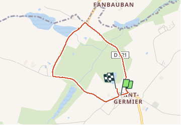
14.1 km | 16.2 km-effort
2h 55min
Yes
Trail Walking Sanxay - sanxa6 - Photo
Walking
Nananananananana

Walking

Medium
Sanxay, New Aquitaine, Vienne, France
8.6 km | 10 km-effort
1h 44min
Yes


Close
My subscriptions