


la boulinie

Patricew
User
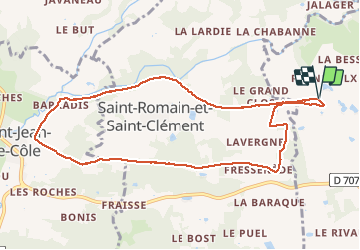

Length
9.8 km

Max alt
259 m

Uphill gradient
161 m
Km-Effort
12 km

Min alt
157 m

Downhill gradient
160 m
Boucle
Yes
Creation date :
2021-04-18 14:07:58.778
Updated on :
2021-04-21 12:19:43.747
1h54
Difficulty : Easy

FREE GPS app for hiking
 SityTrail
IGN / Geographical institutes
SityTrail Plus
The world is yours!
About
Trail Walking of 9.8 km to be discovered at New Aquitaine, Dordogne, Thiviers. This trail is proposed by Patricew.
Description
belle randonnée de 10 km assez facile
Départ voie verte, allez jusqu'à Saint Jean de Cole par voie verte, suivre le parcours
Pas de problème particulier
Positioning
Country:
France
Region :
New Aquitaine
Department/Province :
Dordogne
Municipality :
Thiviers
Location:
Unknown
Start:(Dec)
Start:(UTM)
335008 ; 5032479 (31T) N.
Comments