


chapelle maillée

jmperi
User
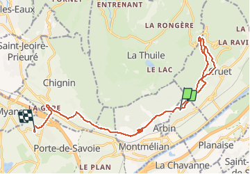

Length
17 km

Max alt
748 m

Uphill gradient
689 m
Km-Effort
26 km

Min alt
292 m

Downhill gradient
762 m
Boucle
No
Creation date :
2021-04-23 12:07:46.113
Updated on :
2021-04-23 14:53:21.65
2h45
Difficulty : Medium

FREE GPS app for hiking
 SityTrail
IGN / Geographical institutes
SityTrail Plus
The world is yours!
About
Trail Mountain bike of 17 km to be discovered at Auvergne-Rhône-Alpes, Savoy, Arbin. This trail is proposed by jmperi.
Positioning
Country:
France
Region :
Auvergne-Rhône-Alpes
Department/Province :
Savoy
Municipality :
Arbin
Location:
Unknown
Start:(Dec)
Start:(UTM)
271289 ; 5044244 (32T) N.
Comments